Thursday, September 25, 2014

Puerto Rico Destinations - Rincón

Rincon

Rincón is a municipality of Puerto Rico founded in 1771 by Don Luis de Añasco (Founder of Añasco in 1733). It is located in the Western Coastal Valley, west of Añasco and Aguada. Rincón is spread over 9 wards and Rincón Pueblo (The downtown area and the administrative center of the city). It is part of the Aguadilla-Isabela-San Sebastián Metropolitan Statistical Area. The word "Rincón" means corner. Rincón is on the northwestern part of Puerto Rico.
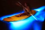
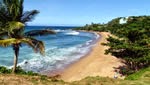
It is home to many of the surfing beaches in Puerto Rico, including Domes, Marias, Tres Palmas, Sandy Beach, Pools Beach, and Rincon Town Beach Plaza. It is also home to Caribbean beaches including Córcega Beach. The half-dozen reef-lined Atlantic beaches have become a winter mecca for skilled surfers since the World Surfing Championship was held here nearly twenty years ago. Endangered humpback whales visit in the winter.

Rincon is known for water sports and deep sea fishing, but there are so many other activities to fill out your vacation. You'll find sunset cruises, parasailing, and horseback riding , along with whale watching and healthy living activities among many other fun day trips and tours in and around Rincon and Western Puerto Rico.

Geography

 Land Area:  36 sq km (13.8 sq mi) The town of Rincón is located in the Western Coastal Valley, west of Añasco and Aguada. To the north, nestles between "La Cadena" Mountains and a series of beaches facing the Atlantic to the north and the Caribbean to the south.

Attractions

  • Domes Beach
  • María's Beach
  • Steps Beach
  • Macor by the Sea
  • Sailing
  • Balneario de Rincón
  • Punta Higüeras Light was built by the Spaniards in the early 1890s and rebuilt after an earthquake in 1921. This working lighthouse uses an unmanned 26,000-candlepower rotating beacon.
  • Rincón Pottery: Working studio and gallery in Cruces, Rincón. Offers "Hands on Clay" workshops.
  • Bonus Nuclear Plant
  • Tres Palmas Coral Reef Reserve
  • Surf Town
  • The Spanish Wall
  • Rincon Skate Park (indoor SK8 street course)
  • Festivals and Events
  • Whale Festival - Oct
  • Rincón International Film Festival 2011: April 12–16
  • Coconut Festival (Festival del Coco) - May
  • Feast of the Patron Saint (Fiestas Patronales), Santa Rosa de Lima - August
  • Triatlon and Triatlon Caribbean Cup
  • Numerous Surfing Championships
  • Local Band (Reggae and Latin Rock)
  • Every year, Rincón celebrates a patron saint festival. The festivities include dances, food, parades and religious processions. (787) 823-2575

Surfing


Rincon is well known as a place to surf. What put Rincón on the map was the 1968 World Surfing Championship, held at Domes and Maria's Beaches. The winter surf along Rincón's coast is some of the best in the region. Generally regarded as one of the best surf spots across the globe, Rincón draws surfers from around the world. Rincón is the center of the island surf scene. Dubbed the "Caribbean's Hawaii," winter waves here can approach 25–30 feet (6.7m) in height, sometimes equaling the force of the surf on Oahu's north shore. Famed surfing beaches in town include Little Malibu, Tres Palmas, Maria's, Indicators, Domes, Pools, Sandy Beach and Antonio's. The best time to surf is from November through March, but summer storms can also kick up the surf during the late summer.

 Best West "Sunset" Points

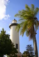
Puerto Rico's west shore "sunset points"; Barrero Beach, Corcega Beach, Steps Beach, Maria’s Beach and The Rincon Lighthouse for great sunset viewings.
GPS coordinates for the above sunst spots...
Corcega Beach: (18.329653, -67.251611)
Maria's Beach: (18.357553, -67.269241)
Steps Beach: (18.349821, -67.264647)
Rincon Lighthouse / El Faro de Punta Higuero: (18.362007, -67.270585)


Beaches GPS Coordinates along Rincón's costline
Tourism Association of Rincon for more! - Rincon - rincon.org -
 
 
Stay with us at Villas de Costa Mar for clean, safe, secure, comfortable accommodations in Dorado Puerto Rico and do day trips to anywhere in the island. Directions and instructions in our rentals and on our website... 
VillasdeCostamar.com


Tuesday, September 23, 2014

Puerto Rico Destinations - Fajardo

Fajardo

Fajardo is known as "La Metrópolis del Sol Naciente" (the city that guards the sun of the Caribbean). Fajardo was founded in 1772. It was originally named Santiago de Fajardo. It was one of the locations used by the Americans to invade Puerto Rico. On August 1, 1898 the USS Puritan under the command of Captain Frederic W. Rodgers, was sailing by the coastline of the city of Fajardo, when Rogers noticed the "Faro de Las Cabezas de San Juan" (Cape San Juan lighthouse) which was supposed to be the landing site for the US Army in Puerto Rico. Rodgers ordered some of his men ashore, which included Puerto Rican volunteers, with the mission of posting the American Flag atop the lighthouse.

Geography

Fajardo is a small city and municipality in Puerto Rico located in the east region of the island, bordering the Atlantic Ocean, north of Ceiba and east of Luquillo.  Area: 60.41 sq miles (156.4 km²), Population: 36,499 (2011).
Isleta Marina pictured here

Attractions
One of the main attractions is the Bio-Luminescent Bay. A 1.5 hour tour, you will kayak in through a Mangrove forest at night to the bay, where luminescent plankton glow bright blue every time the water is disturbed. Most tours cost $45, and combo packages with tours of El Yunque Rainforest are available and quite a good full-day trip.

Other attractions/locations are listed below...
  • Faro de Fajardo, Route 987, 860-2560. Featuring a nature center and working 19th century lighthouse. Watch your step in the neighborhoods around the ferry terminal, there is an iguana infestation and many dead three foot long lizards litter the streets. The locals just step over them as if it's no big deal.
  • Icaco, Palomino and other offshore islands of Puerto Rico.
  • El Yunque Rain Forest. El Yunque Caribbean National Forest is the only tropical rain forest in the US National Forest System. El Yunque occupies 28,000 acres and it is more than 3,500 feet above sea level. The annual rainfall is extremely heavy. It receives more than 100 billion gallons per year.
  • Puerto del Rey Marina is a marina located in Fajardo, Puerto Rico. With a capacity of 1,100 boats, it is one of the largest marinas in the Caribbean.
  • Laguna Grande - One of the few Bioluminescent bays in the world.
  • U.S. Customs House - Constructed in 1930 still in use by the U.S. Customs & Border protection.
  • Santiago Apostol Cathedral
  • El Conquistador Resort - One of Puerto Rico's most luxurious resorts, complete with its own private, 3 ft 10 in (1,168 mm) narrow gauge funicular railway connecting its main hotel building with its marina.
  • Seven Seas Beach - One of the most beautiful beaches on the island. Classified Blue Flag for its sanitary health guarantees.
  • Las Cabezas de San Juan Reserve - Home to mangroves and to the lighthouse.
  • Fajardo Port - Used by locals and tourists to visit the island municipalities of Vieques and Culebras.
  • Town Square - One of the most charming, antique styled, town squares of Puerto Rico. It has free wireless internet.
  • Old Fajardo Sugar Cane Refinery
  • Isleta Marina
  • Natural Reserve Las Croabas
  • Las Croabas Recreational Park
  • Hipolito Robles Sports Complex

Beaches


Fajardo's beaches are bounded by calm, clear water ideal for snorkeling. Seven Seas Beach offers plentiful water sports facilities, offshore points for sailing, snorkeling and plenty of scuba diving.
Seven Seas Beach, with crystal blue waters and a beautiful sand beach located at Las Cabezas de San Juan, 5 minutes from the town of Fajardo and in the Las Croabas sector. The clear shallow water is teeming with vibrant tropical fish and coral reefs and is protected by offshore reefs. The region is part of the National Parks system and is considered a "World Blue Flag Beach". In order to obtain the Blue Flag distinction, a beach has to comply with a set of very strict standards in terms of water quality, safety and services, environmental education and information. Blue Flag Beaches are continually monitored for water and land environmental safety.

Playa Escondida and Playa Colora are two of the most secluded beaches you can find. This means that it is a romantic spot, it's certainly a great place for snorkelling and just to relax. Playa Escondida means "hidden" and Playa Colora "hot beach" in Spanish. In order for it to be hidden, and virtually unused, it is in an out-of-the way place — you have to walk about 15 to 20 minutes through a mangrove forest to get there. But the prize at the end is worth it — finding a pretty, secluded strip of beach like this one is always a pleasure. Also the Governor's summerhouse is at Playa Escondida. Playa Escondida is very safe for snorkelling, swimming and/or just to contemplate the beautiful views in very calm non-wave waters.

Map of Fajardo

Fajardo map with Villas de Costa Mar's driving direction's… Fajardo Map

Articles

Puerto Rico Vacation: Our Easy, Kid-Friendly Guide

Villas de Costa Mar's LogoStay with us at Villas de Costa Mar for clean, safe, secure, comfortable accommodations in Dorado Puerto Rico and do day trips to anywhere in the island. Directions and instructions in our rentals and on our website...
 
VillasdeCostamar.com

Monday, September 22, 2014

Puerto Rico Destinations - San Juan


1      San Juan


Code of Arms, San Juan PRSan Juan is one of Puerto Rico's most important seaports, and is the island's manufacturing, financial, cultural, and tourism center. The population of the Metropolitan Statistical Area, including San Juan and the municipalities of Bayamón, Guaynabo, Cataño, Canóvanas, Caguas, Toa Alta, Toa Baja, Carolina and Trujillo Alto, is about 2 million inhabitants; thus, about half the population of Puerto Rico now lives and works in this area. San Juan is also a principal city of the San Juan-Caguas-Fajardo Combined Statistical Area. The city has been the host of events within the sports community, including the 1979 Pan American Games, 1966 Central American and Caribbean Games, events of the 2006, 2009 and 2013 World Baseball Classics, the Caribbean Series and the Special Olympics and MLB San Juan Series in 2010.
 
Geography

San Juan is located along the north-eastern coast of Puerto Rico. It lies south of the Atlantic Ocean; the city occupies an area of 76.93 square miles (199.2 km2), of which, 29.11 square miles (75.4 km2) (37.83%) is water. San Juan's main water bodies are San Juan Bay and two natural lagoons, the Condado and San José


You cannot cover San Juan without including Old San Juan (Spanish: Viejo San Juan or San Juan Antiguo) is the oldest settlement within Puerto Rico and is the historic colonial section of San Juan, Puerto Rico. It was listed on the U.S. National Register of Historic Places in 1972 as "Zona Histórica de San Juan" (San Juan Historic Site), and declared a National Historic Landmark District in March 2013. Some of Old San Juan streets are still paved with blue cobblestones from the Spanish colonial era.
 

Attractions

Castillo San Felipe del MorrowThe main attraction in Puerto Rico’s San Juan is Old San Juan and its many attractions starting with the paved blue cobblestones streets from the Spanish colonial era. Old San Juan’s main attraction is Castillo San Felipe del Morro. San Juan National Historic Site includes Castillo San Cristóbal, Castillo San Felipe del Morro, Fortín San Juan de la Cruz known locally as El Cañuelo, and three fourths of the city walls. Other places to visit are listed below with a link to walking map and more on listed attractions…


Follow this link to more on the above attractions and walking tours map of Old San Juan. Old San Juan Map!
  •  Paseo de la Princesa
  • Puerta de San Juan
  • Plazuela de la Rogativa
  • La Fortaleza
  • Capilla del Cristo
  • Catedral de San Juan Baurista
  • Meseo Pablo Casals
  • Iglesia de San José
  • Casa Blanca
  • Castillo San Cristóbal
  • Plaza de Colon

Beaches in San Juan

BEACHES IN SAN JUAN
Name
Location
Coast
Isla Verde, Eastern part of San Juan
East
Condado District, Central San Juan
North East
1.8 mi. East of Old San Juan
South East
Isla Verde, Central San Juan
East
Ocean Park, Central San Juan
North East
Condado District, Central San Juan
North East

 Transportation in Puerto Rico
Follow the below URL link for information and links to more information on the following methods of transportation in Puerto Rico…
  • Taxi
  • Walking
  • Bus
  • Minibus (Publicos)
  • Rental Cars
  • Metro (Tren Urbano
  • Ferry
Puerto Rico page on Villasdecostamar.com


 Stay with us at Villas de Costa Mar for clean, safe, secure, comfortable accommodations in Dorado Puerto Rico and do day trips to anywhere in the island. Directions and instructions in our rentals and on our website...
 
VillasdeCostamar.com